Priority Areas
Our focus on priority populations and habitats inevitably led to recommendations for specific conservation actions at specific places in the LGBFR AOC. To help restore wildlife and habitats, we've identified priority areas that ultimately will be instrumental in helping achieve the BUI removal targets for fish and wildlife habitats and populations.
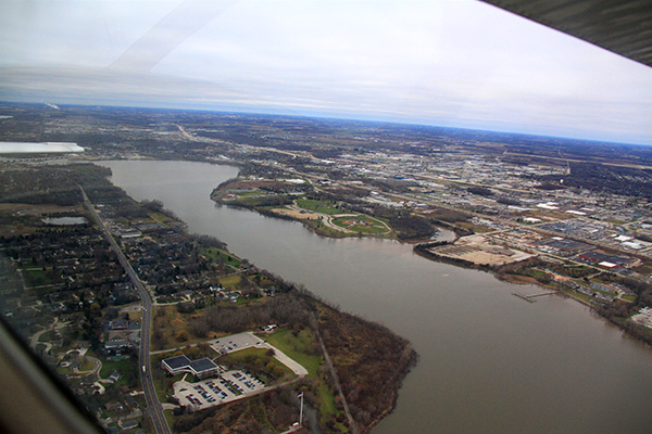
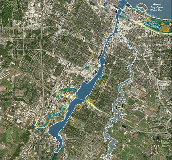
Fox River
The Fox River is a third order stream that flows northeast and forms the basis of the Lower Fox River basin, which is 1,654 km in size. The lower Fox River starts from Lake Winnebago and empties into Green Bay, which is the western arm of Lake Michigan. The priority area only includes the Fox River open water from the mouth of the Fox River to the De Pere Dam. The East River, Ashwaubenon Creek and Dutchman Creek are smaller second order streams that empty into the Fox River.
Unfortunately, water quality in the lower bay and Fox River has been poor for decades. The LGBFR AOC was originally listed as a Great Lakes Area of Concern in 1988 due to poor water quality, contaminated sediments and degraded or lost habitat and has a long history of pollution. Since 2009, the Fox River Cleanup Project has been working to dredge up historic polychlorinated biphenyls (PCB) in 20.92 km (13 mi) that are found in Fox River sediment. Waters within the LGBFR AOC regularly report high concentrations of total phosphorus, total suspended solids, nitrates/nitrates and toxic chemicals, leading to poor overall water quality. It can also be turbid and experience summer and late fall blooms of harmful algae. Fox River waters often contain low levels of oxygen, especially in the summer, which can be deadly for fish. The land surrounding the Fox River between the De Pere Dam and mouth of the Fox River is heavily industrialized and urbanized, creating a significant amount of impervious surfaces, which contributes to the nutrient runoff problem.
Despite water quality issues, a great number of wildlife still use the Fox River, especially fish species. Over the past several decades, scientists from agencies, non-profit organizations, universities and other organizations have conducted dozens of research projects and collected data on fish, water quality, odonates, bats, birds, anurans (frogs and toads) and plants.
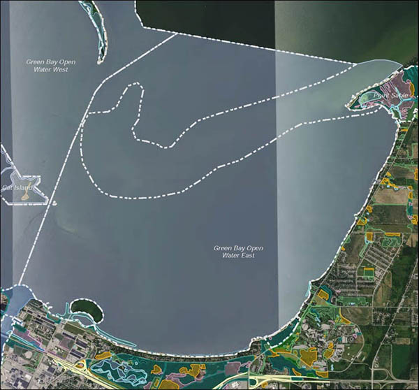
Green Bay Open Water East
The Green Bay Open Water East priority area consists of the eastern half of the open water/pelagic zone of the lower bay of Green Bay, which is the western arm of Lake Michigan. It is somewhat arbitrarily distinguished and separated from the Green Bay Open Water West priority area by the shipping channel, though there are some distinct differences between the eastern and western halves of the bay.
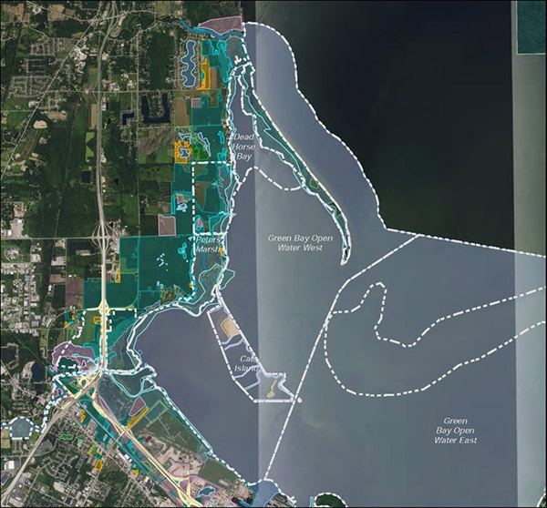
Green Bay Open Water West
The Green Bay Open Water West priority area consists of the western half of the open water/pelagic zone of the lower bay of Green Bay, which is the western arm of Lake Michigan.
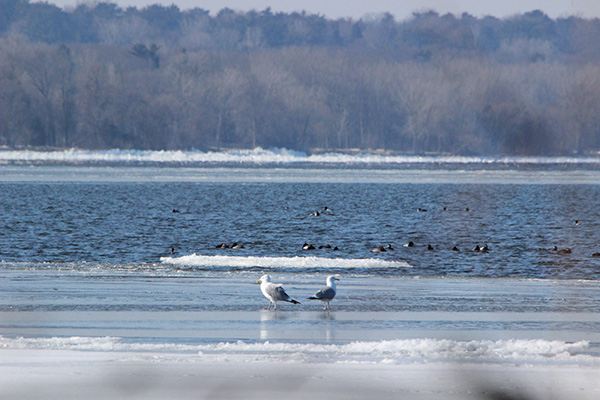
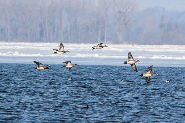
Despite water quality issues, a great number of fish and wildlife still use the lower bay’s pelagic zone. The Green Bay Open Water West (and East) priority area is extremely well studied and may in fact be one of the most studied priority areas in the LGBFR AOC.

Bay Shore Woods & Beach
Bay Shore Woods and Beach is a priority area located within the western corner of the UW-Green Bay campus and is a part of the Cofrin Memorial Arboretum. The property is owned and managed by the UW-Green Bay Cofrin Center for Biodiversity (CCB), though the City of Green Bay owns two small parcels. It primarily follows the bay of Green Bay shoreline and almost entirely consists of hardwood swamp, though emergent high energy marsh and Great Lakes beach are found along the shoreline.
Great Lakes beach is a relatively rare habitat within the LGBFR AOC as well as within the state of Wisconsin; nearly 0.7 km of beach traces the shoreline of this priority area. The northeastern half of this priority area consists of Keowns silt loam soils, while the southwestern half is Allendale loamy fine sand along the shoreline and Poygan silty clay loam soils in the forested areas. Although several invasive plant species frequent parts of the hardwood swamp and shoreline, it still supports ~180 bird species annually (both migratory and breeding), known odonate (dragonflies and damselflies) species, 30+ fish species offshore and several mammal and reptile species. Because UW-Green Bay owns this priority area, it is extremely well-studied by university and agency scientists, particularly for plants, birds and some arthropods. CCB staff have also been actively managing invasive plant species, especially understory woody plants (e.g., glossy buckthorn (Frangula alnus), to try and improve these important wildlife habitats.
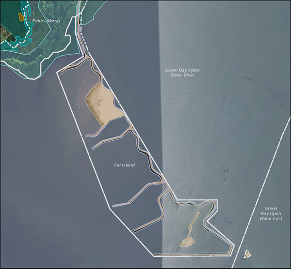
Cat Island
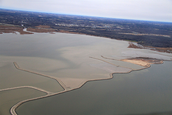
The Cat Island Wave Barrier is a ~4.5 km long causeway that extends into the open bay of Green Bay from Peters Marsh along the southern west shore. Off the causeway/wave barrier are three artificial island “cells” with “legs” extending off the main road/causeway. Due to extremely high water levels in the bay, massive storms and hardened shorelines, three barrier islands washed away during the spring of 1973 with the exception of a few small sandy islands, including parts of Cat Island. The huge emergent and submergent marshes of the Duck Creek Delta complex also vanished because the islands no longer provided the much-needed protection and because of high sediment loads further upstream.
In the 1980s, a group of local conservationists proposed the idea of reconstructing these three barrier islands and formalized the idea in the LGBFR AOC’s 1988 Remedial Action Plan. It took decades of extensive planning and acquiring funding for that idea to materialize and become a reality. They collaborated with Brown County, Brown County Port and Resource Recovery Office and U.S. Army Corps of Engineers (USACE) and decided to reconstruct these islands. Over time, the Cat Island Wave Barrier and island “cells” were eventually constructed by May 2013.
Although the project will not be fully completed for another 20 to 30 years, many fish and wildlife have already been documented using the relatively new dredge material, which consists of sand and clay, in the westernmost island “cell,” including the federally and state endangered shorebird, the Piping Plover (Charadrius melodus). Piping Plovers have not been recorded nesting in lower Green Bay in over 70 years and were only previously known to nest on Longtail Point and Little Tail Point. This project site is also currently considered the best shorebird migratory stopover site in the entire state of Wisconsin. Many research projects are currently taking place as scientists and managers explore the re-establishment of submergent and aquatic plants and the responses of fish and wildlife.
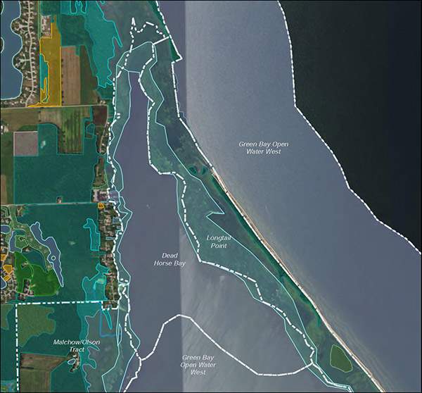
Dead Horse Bay
Dead Horse Bay is a part of Green Bay’s west shore wetland complex and has been called the “armpit” of Longtail Point being sandwiched in between the west shore and Longtail Point. It largely consists of open water as well as one of the largest and highest quality submergent marshes in the entire LGBFR AOC, which includes a few small pockets of wild celery (Vallisneria americana) along this priority area’s eastern border adjacent to Longtail Point. Rafts of over 20 migratory waterfowl species have been reported within Dead Horse Bay in 2016 and 2017 within the open water and submergent marsh.
Dead Horse Bay is popular for fishing and duck hunting. While there are extensive beds of native submerged aquatic vegetation, there is great potential for this site to be enhanced and expanded as well as managed for invasive plant species, such as Eurasian watermilfoil (Myriophyllum spicatum). Several research projects have taken place in Dead Horse Bay in recent years, including multiple fish studies (e.g., WDNR, U.S. Fish and Wildlife Service, UW-Green Bay), submerged aquatic vegetation survey (UW-Green Bay), migratory waterfowl survey (UW-Green Bay) and invertebrate study (UW-Green Bay).
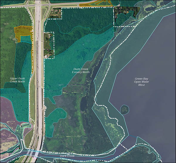
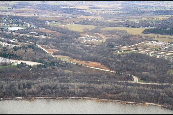
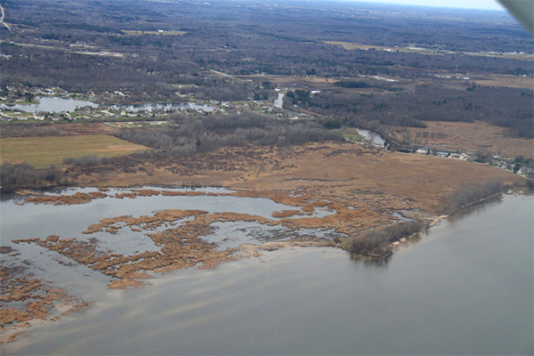
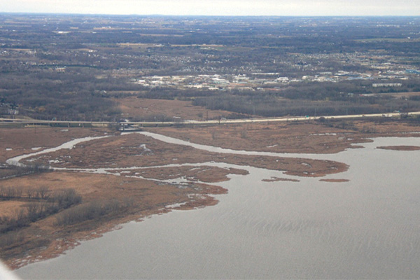
Duck Creek Estuary North
Duck Creek Estuary North is located north of the mouth of Duck Creek alongside Interstate 41 and is a part of the Duck Creek Delta wetland complex. While the priority area has been significantly modified over the years from development, road construction and agricultural/storm water runoff, it still features a natural hydrologic gradient that grades from submergent/emergent marsh into southern sedge meadow, shrub carr and hardwood swamp.
The huge Duck Creek Delta wetland complex vanished because the islands no longer provided the much-needed wave/storm protection. However, the hope is that this once extensive submergent and emergent marsh will reform in the coming years given the right conditions and lake levels when the Cat Island Wave Barrier project is completed in the next 20 to 30 years.
Including the Duck Creek Estuary North priority area, the Duck Creek Delta is a heavily studied area in the lower bay. Researchers and managers from the Wisconsin Department of Natural Resources (WDNR), U.S. Fish and Wildlife Service (FWS), UW-Green Bay and Oneida Nation of Wisconsin have conducted studies on plants, animals and water quality as well as multiple restoration efforts, including the attempt to re-establish wild rice. Because of the added protection of the Cat Island Wave Barrier and pockets of relatively good quality habitat, the Duck Creek Estuary North priority area has great potential to be improved and restored and should be considered a high priority restoration site.
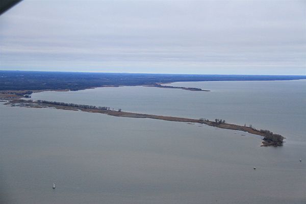
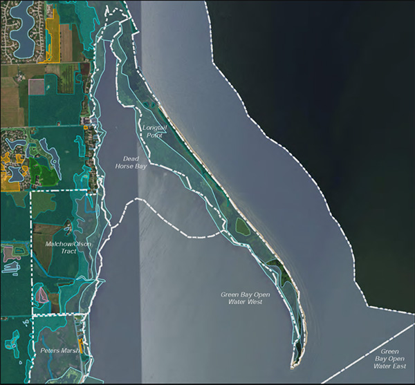
Longtail Point
Longtail Point is a peninsula that extends 5 km into lower Green Bay along the west shore in the Village of Suamico. It constitutes the LGBFR AOC’s northwestern-most border, and to the southwest of it in its wave shadow is Dead Horse Bay.
Despite the fact that Longtail Point is invaded by Phragmites australis (common reed) and the hybrid cattail (Typha × glauca), it is still an important migratory waterfowl stopover site, nursery habitat for many fish species and breeding habitat for marsh birds. Because it is publicly owned, the quality and integrity of Longtail Point may be threatened by heavy recreational use (e.g., boating). However, there is great potential for this site to be enhanced in terms of the quality of its emergent marsh and other habitats. Within the past five years, the Wisconsin Department of Natural Resources has been proactive in terms of tackling the widespread issue of Phragmites in the bay of Green Bay. In 2011, 2012 and 2015, they conducted large-scale aerial and ground sprayings of Phragmites along the west shore and other areas, including Longtail Point.
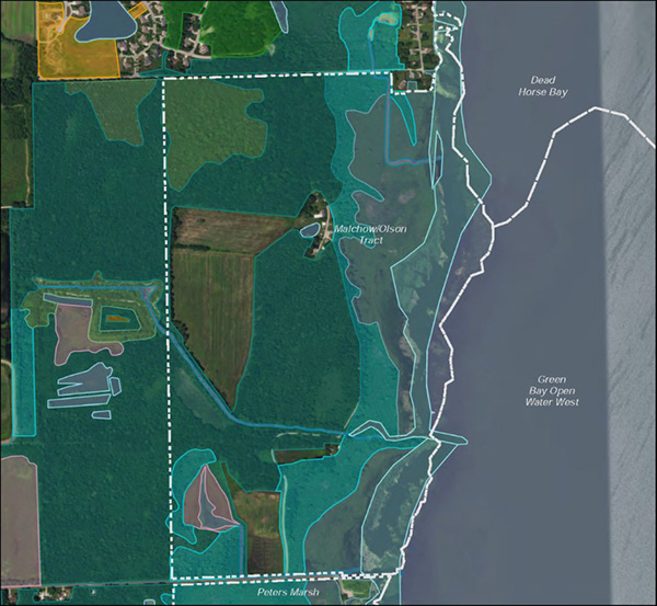
Malchow/Olson Tract
The Malchow/Olson Tract is a relatively large, privately owned priority area located along the west shore of the bay of Green Bay just south of Longtail Point, which constitutes the LGBFR AOC northwestern-most border. Thanks to this family’s perseverance, led by Eileen Olson (Gordon and Ethel Malchow’s daughter) and her relatives, the Malchow/Olson Tract has largely been untouched and undisturbed over the past 100+ years with the exception of the family’s farmland and houses.
Within the entire LGBFR AOC, parts of this property’s emergent marsh and nearly all of its hardwood swamp have the highest ecological quality for these habitat types because they have high native plant diversity and little to no invasives. It is one of the few places in the LGBFR AOC that still contains the historical mosaic of submergent and emergent marsh that naturally grades into southern sedge meadow, shrub carr and hardwood swamp. It provides critical habitat for northern pike (Esox lucius), muskrats, breeding and migratory birds and migratory waterfowl offshore and is a refuge for many native plants that are locally uncommon to the LGBFR AOC. A few invasive plants have been found here in recent years, including common reed (Phragmites australis) and reed canary grass (Phalaris arundinacea); however, the Wisconsin Department of Natural Resources has treated Phragmites with aerial spraying from 2011 to 2012 and on the ground treatment from 2015 to 2016. Because of these efforts, the amount of Phragmites present today is very minimal.
Based on what is currently known, every effort should be made to protect this property because it provides essential fish and wildlife habitat, which helps support sustainable health fish and wildlife populations within the LGBFR AOC.
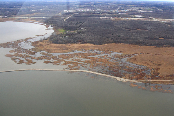
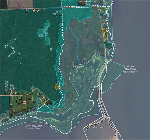
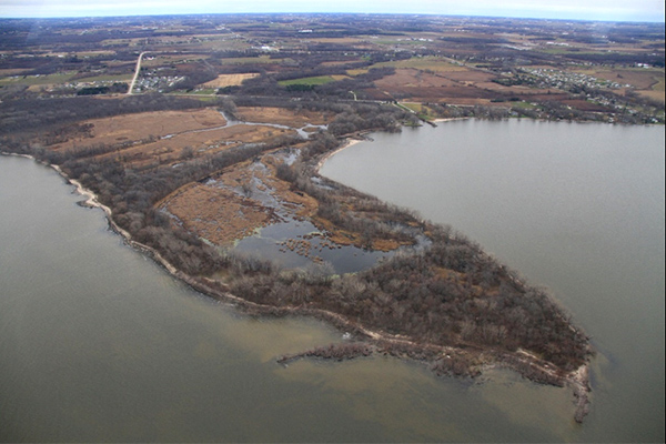
Peters Marsh
Peters Marsh is a relatively large priority area located along the west shore of the bay of Green Bay just south of Lineville Road that is almost entirely publicly owned by Brown County and the Wisconsin Department of Natural Resources. Its eastern border is protected from wave action by Bayshore Drive and the Cat Island Wave Barrier (fully constructed in 2013), though the southern part of the marsh is open and exposed to the bay, seiche and wave action.
Depending on lake levels, it is primarily dominated by emergent and submergent marsh that naturally grades into shrub carr. Unfortunately, most of the emergent marsh is dominated by a monoculture of the invasive hybrid cattail (Typha × glauca), common reed (Phragmites australis), and reed canary grass (Phalaris arundinacea), quite unlike the historical assemblage of native plants that formerly were dominants, which includes sedges, wild rice (Zizania aquatica), wild celery (Vallisneria americana) and cattails (Typha latifolia). Despite its current extremely low native plant diversity, it provides critical habitat for muskrats, anurans (frogs and toads), breeding and migratory marsh birds, waterfowl, fish and insects.
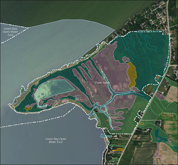
Point au Sable
Point au Sable is a peninsula located along the eastern shore of the bay of Green Bay, approximately 10 km northeast of the city of Green Bay (in the town of Scott), and constitutes the LGBFR AOC northeastern-most boundary. It consists of a wide variety of habitats including emergent marsh, hardwood swamp, Great Lakes beach and a small patch of southern sedge meadow. In fact, the Point contains one of the largest remaining Great Lakes coastal wetlands along the bay of Green Bay’s eastern shore.
Today, Point au Sable is primarily owned by UW-Green Bay and managed by the Cofrin Center for Biodiversity (CCB), though some of it is privately owned. Even though several aggressively invasive plant species are frequently dominant in parts of the Point, it still supports over 200 bird species annually and is an extremely important migratory bird stopover location for many waterfowl, Neotropical migrant songbirds and shorebirds. It is also an important nursery for yellow perch (Perca flavescens), provides spawning habitat for northern pike (Esox lucius) and is home to over 40 species of fish in Wequiock Creek and offshore areas.
Because UW-Green Bay owns most of the Point, it is extremely well-studied by university and agency scientists. CCB staff have been heavily treating and managing invasive plant species, especially the common reed (Phragmites australis) and understory woody plants (e.g., showy bush honeysuckle [Lonicera × bella]).
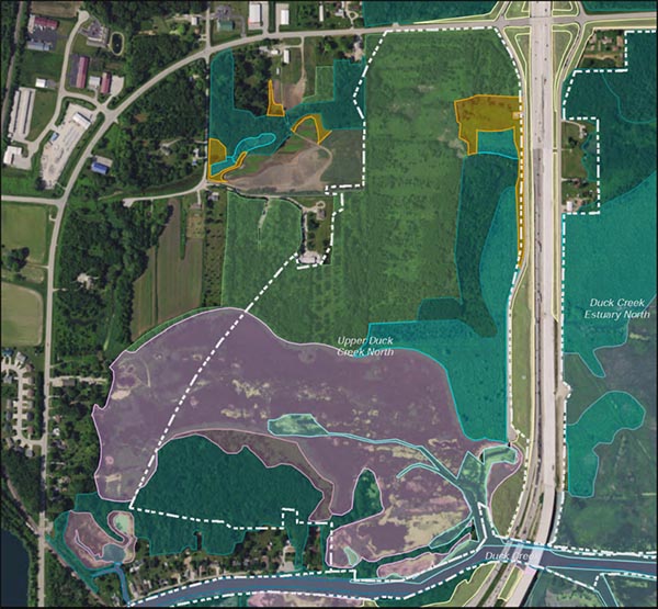
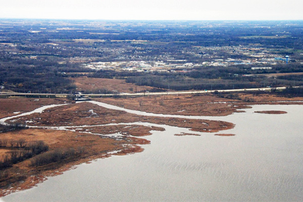
Upper Duck Creek North
Upper Duck Creek North is located just west of the mouth of Duck Creek and Interstate 41 and is a part of the Duck Creek Delta wetland complex. While the priority area has been significantly modified over the years from development, road construction and agricultural/storm water runoff, it still features a hydrologic habitat gradient that grades from submergent/emergent marsh into southern sedge meadow, shrub carr and hardwood swamp. While the emergent marsh is heavily dominated by the invasive, hybrid cattail (Typha × glauca), parts of the shrub carr and especially southern sedge meadow have good quality plants, though restoration would significantly improve their overall ecological quality.
While many parts of the Duck Creek Delta are heavily studied in the lower bay, the Upper Duck Creek North priority area is not well studied, at least not in recent years. By the fall of 2012, the Oneida Nation of Wisconsin removed two dams and modified an existing dam upstream in Pamperin Park, which improved fish habitat for species such as northern pike (Esox lucius). The UW-Green Bay’s CCB led a LGBFR AOC bird survey in 2015, habitat mapping effort in 2015, plant biodiversity hotspot mapping and inventory in 2016 and submerged aquatic vegetation mapping in 2017. All surveys included visits to the Upper Duck Creek North priority area. The WDNR has also conducted an aerial spraying of herbicide to manage common reed (Phragmites australis) along the west shore. They sprayed this priority area’s emergent marsh in 2012.
Ask an Expert
Meet Erin Giese, Associate Director of the Cofrin Center for Biodiversity. She's President of the Northeastern Wisconsin Bird Alliance, principal investigator for the Great Lakes Coastal Wetland Monitoring Program and administrator of the annual CCB Student Grant Program. If you have questions, she can help!